
Tagged: conservation
NCC resources and land management: problems and possible solutions
By Bailey Cooke
Bailey Cooke is a second-year University of Ottawa student in biology and geology. This winter, Bailey is volunteering with the OFNC through the Community Service Learning program.
On Wednesday, February 18, the Ottawa Field-Naturalists’ Club held a workshop at the Fletcher Wildlife Garden to discuss natural history conservation in the Ottawa-Gatineau region. The evening kicked off with a presentation by Eva Katic from the National Capital Commission (NCC). Eva, manager of Natural Resources and Land Management – Greenbelt talked about various ongoing conservation initiates on NCC lands. A brief Q&A and an open discussion followed the presentation.
What is the NCC? What do they do?
Created in 1959, the NCC is a crown corporation of the government of Canada that seeks to protect, preserve, and promote natural heritage in the Ottawa-Gatineau region. The NCC administers land-use planning, water management, biodiversity conservation, and the sustainable use of resources, in various areas throughout the region, such as Gatineau Park, the Greenbelt, urban lands, official residences, and leased lands.
These lands are home to abundant wildlife and many rare species like the Eastern Red-cedar and the Peregrine Falcon. Over 27 ecologically valuable ecosystems & habitats have been identified; the NCC aims to conserve these areas.


Why conserve these lands?
Aside from their rich biodiversity and critical habitats, there are other compelling reasons for conserving these regions. The 55 identified at-risk species that find refuge on these lands leave the NCC with legal and ethical obligations to protect their habitat. Conserving these lands also mitigates risk to the water quality of nearby campsites and beaches, and aids control of waterborne diseases. NCC’s conservation efforts protect its lands from some of the land-use pressures that profoundly affect adjacent areas: habitat fragmentation, pollution and dumping, and unauthorized activities (ATVs, campfires). Control of invasive species (Emerald Ash Borer, Dog-strangling Vine, etc.) is imperative, as they are the second most important cause of biodiversity loss in the area. Another concern is the overabundance of some species that pose a risk to human safety and also alter ecosystem processes. As an example, Eva mentioned the White-tailed Deer’s herbivory of native vegetation, which is having a significant effect on forest succession.
What are some of the NCC’s current management efforts?
During her presentation, Eva outlined a few major management projects and scientific studies that have either been her focus in the last decade or will be the focus of upcoming years.
The Greenbelt Master Plan
In 2013, the NCC identified the Greenbelt as being crucial to natural ecosystems, agriculture, and outdoor recreation/educational opportunities. The NCC aims to increase local and international recognition of the Greenbelt, making it a welcoming outdoor space in the capital.
Natural areas in the Greenbelt increased from 50% in 1996 to 61% in 2013 and continue to be managed by the NCC. Currently, Greenbelt sectors such as Shirley Bay, Stony Swamp, Southern Farm/Pinhey Forest, the airport, Pine Grove, Mer Bleue Bog, and Green Creek are some of the regions of conservation focus by the NCC.


Restoration projects
- Pinhey Sand Dune: Along with the Biodiversity Conservancy, the NCC is working toward restoring three open sandy areas that are connected by trail to the Pinhey Sand Dune site to enhance the experience of Greenbelt visitors. (More about the project and winners of OFNC 2012 Conservation Award)
- Black Rapids Creek: The creek flows east from Greenbank Road (NCC experimental research farm) to Prince of Wales Drive (Black Rapids Locks), where it empties into the Rideau River. In partnership with the Rideau Valley Conservation Authority (RCVA), the NCC seeks to restore the wetlands adjacent to Black Rapids Creek.
Research projects
- Bird monitoring – Least Bittern: This project involves volunteers locating and monitoring the Least Bittern in Ramsey Marsh (Greenbelt, Mer Bleue Bog).
- Stony Swamp – Dog-strangling Vine: The NCC is conducting a 5-year pilot project (2013-17) to determine how to control this invasive species in Stony Swamp. Tarping, cutting, and spraying methods have already resulted in the removal of 72 patches of Dog-strangling Vine.
- Butterfly habitat – Monarch: In the coming season, the NCC hopes to partner with multiple levels of government, local universities, and local stakeholders to restore meadow habitats to enhance Monarch butterfly habitat in the Greenbelt and urban lands.
What can we do?
The NCC is seeking volunteers to help with the documentation of bird species and the restoration of meadow habitat beginning this summer. A familiarity with bird identification is an obvious asset. Volunteer labourers for forest/wetland restoration and to tackle threats to healthy habitats (invasive species removal) are also needed. Please contact ottawaofnc@gmail.com for further information on how to get involved in these initiatives.
A Conservation Plan for the Ottawa Valley
By Jessica Sutton
Jessica Sutton is a 2nd-year University of Ottawa student in Environmental Studies and Biology. This fall, Jessica is volunteering with the OFNC through the Community Service Learning (CSL) program.
Report from the 2014 Youth Summit
The November monthly meeting kicked off with a presentation by Emma Kirke and Emily Pollington – two youth from the Ottawa-Gatineau area who attended the 2014 Ontario Nature Youth Summit in September. The OFNC sponsored Emma and Emily to attend this yearly event that brings together Ontario youth interested in biodiversity and sustainability. The theme for this year’s summit was “Community Action”.

2014 Ontario Nature Youth Summit attendees. Photo: Brendan Toews
Emma and Emily talked about the various workshops they participated in:
- Reptile and amphibian ramble – a workshop to try out the Ontario Reptile/Amphibian Atlas Program. The program helps users identify reptiles and amphibians, and users can contribute pictures and sighting details to the atlas.
- How to ‘be the change’ – a workshop about personal and community changes that can be made to better the environment.
- Becoming a hero for sustainability – a workshop about communication and leadership, how to step up and take action on environmental issues, and what to expect with these initiatives.
Other workshops included Ontario’s birds of prey, DIY terrarium, Medicinal plants of Ontario (with an Aboriginal elder instructor), and a Pollinator and pesticide debate about whether or not neonicotinoids should be banned. Since attending the Youth Summit, Emily has applied for a position on the Ontario Youth Nature Council, and Emma has become more active within her school’s Eco-Club. Congratulations to Emma and Emily on a successful summit – the club looks forward to sponsoring local youth to attend next year’s summit.
The Conservation Plan for the Ottawa Valley
Gary Bell, who works for the Nature Conservancy of Canada (NCC), then gave a captivating presentation on NCC’s conservation goals for the Ottawa Valley and how these goals are to be accomplished. In the fall of 2013, the NCC completed a Natural Area Conservation Plan (NACP) for the Ottawa Valley, in collaboration with a number of partners including the City of Ottawa, the National Capital Commission, and the Ontario Ministry of Natural Resources. The new Ottawa Valley NACP plan incorporates a broad area of the Ottawa Valley in both Ontario and Quebec, from approximately Deep River in the west to Hawkesbury in the east. The NACP sets priorities within a 5-year timeframe.

The biggest issue in determining land conservation priorities is first identifying land that will have the greatest conservation impact if protected. This requires a detailed understanding of the species diversity in an area, as well as its vulnerability to threats such as development and invasive species. To determine which areas to prioritize for protection through acquisition, large datasets for the Ottawa Valley were compiled. Based on specific factors (e.g., size of natural area, species diversity and significance, connectivity, invasive species, etc.), all natural areas in the Ottawa Valley were evaluated to identify primary and secondary priorities. Primary priority lands will now focus interest of potential partner organizations for purchase and protection activity.
The Ottawa Valley is rich, with large areas of forests and wetlands. Within the valley, certain rare ecosystem types have been selected as priorities for conservation focus. These include ecosystem types occurring on shallow limestone, including karst and alvar ecosystems. Large core natural areas have also been highlighted as high priorities for conservation.


Gary highlighted some specific priority areas within the Ottawa Valley that have been selected as conservation targets by the NCC in the NACP. Some of these are already well known to OFNC members as high-quality natural areas.
- Alfred Bog – The majority of this large, provincially significant wetland is owned by Ontario Parks and the NCC. During the 1980s and 1990s, the OFNC played a major role in raising funds and public support to purchase and conserve about 95% of the bog. Some remaining privately owned areas are of high priority for protection by NCC.
- Burnt Lands Alvar – There is a high abundance of rare species at this well-known alvar. Much of the alvar is owned by the NCC and managed by Ontario Parks. Remaining areas are conservation priorities for NCC.
- Wolf Grove – This large natural area in eastern Lanark County has a unique association of plant species and provincially significant wetlands. The NCC currently owns a 91-hectare property at Wolf Grove, and the eventual goal is to transform it into much larger protected area, of perhaps up to 500 hectares.
- Plantagenet Cave System – East of Ottawa (off of Old Highway 17), this natural area is home to many rare species and ancient cedars. The area is close to a limestone escarpment and contains the largest sinkhole in Ontario. An asphalt plant is currently being proposed in this area. Many of local residents and property-owners support the area being protected. Some are donating their property.
- Ottawa Valley Caves (Gervais Caves property) – This newly purchased property consists of freshwater, underwater caves that are connected to the Ottawa River. There is immense diversity in these caves: 53 known fish species, and 13 freshwater mussel species are found in pools throughout the caves. One of the most interesting aspects of the Ottawa Valley Caves is the presence of Lake Sturgeon (Acipenser fulvescens), a species at risk. NCC’s recent purchase of this property was made possible by an OFNC donation of funds from the bequest of Violetta Czasak, an OFNC member who passed away last year.
-

- Lake sturgeon. Photo: Eric Engbretson
-
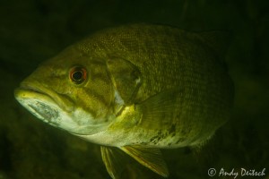
- Smallmouth bass (Micropterus dolomieu). Photo: Andy Deitsch
Overall, the 5-year goals of the NCC are to establish 500 hectares of high priority land in the Ottawa Valley, assist partners in acquiring key lands, and promote partnerships to enhance habitat connection and conservation. To accomplish these goals, the NCC will be promoting science-based site planning, improving our knowledge of key ecosystems, and lastly, raising a whopping $3.8 million.
Hearing about the conservation work of the NCC, especially at a local scale, was very inspirational. Generous and thoughtful donors are helping to conserve and protect many important areas. The OFNC is very proud to play a role in this important work, so that high priority conservation lands may be protected forever.
Staying connected from Algonquin to the Adirondacks
By Natalie Sopinka with geologic descriptions by Ken Buchan
Larose Forest guide now on sale!
At the club’s second last meeting before summer, Linda Burr (Education & Publicity Committee) unveiled the OFNC’s first bilingual publication The Larose Forest, a Naturalist’s Guide. On sale now for $4, the guide includes a description of the forest’s history and habitats by OFNC member Christine Hanrahan, species lists of birds, mammals, herps, butterflies, odonates and vascular plants, plus a colour map of the forest trails. Birding (June 8), mothing (June 13) and butterfly (June 22) walks will be held in the Larose Forest next month. Event details are on the OFNC website.
Emma Kirke, one of the OFNC award winners at the Ottawa Regional Science Fair, was also at the meeting and shared her display on tree crown shape and wind resistance.
Murray Citron captivated the audience with his poetic memories of the “seaside spectacle” that is Newfoundland. While relating tectonic plates to Titans, Murray noted that “where there is geology, there is Greek mythology.”
Where there is geology there may also be a geophysicist like Ken Buchan. In between canoe trips, Ken is a dedicated board member of the Algonquin to Adirondacks (A2A) Collaborative and spoke to OFNC members about the group’s conservation efforts.
The A2A Collaborative’s mission is to “protect, restore, enhance and maintain” connections for wildlife that inhabit and move within the Algonquin to Adirondacks region. The region has a rich geological history that Ken shared. He described how, starting 1300 million years ago, continental collisions formed the Grenville Mountains along the southeastern margin of the Precambrian Canadian Shield. Over hundreds of millions of years they were eroded and partly covered with flat-lying sedimentary rocks to produce the landscape we see today in the A2A region. The Algonquin Highlands and the Adirondack Mountains, as well as the Frontenac Arch which connects them, are part of the Canadian Shield. Although valiant efforts were made to farm on the Arch in the 19th century, it proved unsuitable for agriculture and much of the area has since been reforested. Immediately to the southeast of the A2A region, the Appalachian Mountains were formed during a later series of continental collisions beginning at about 450 million years ago.
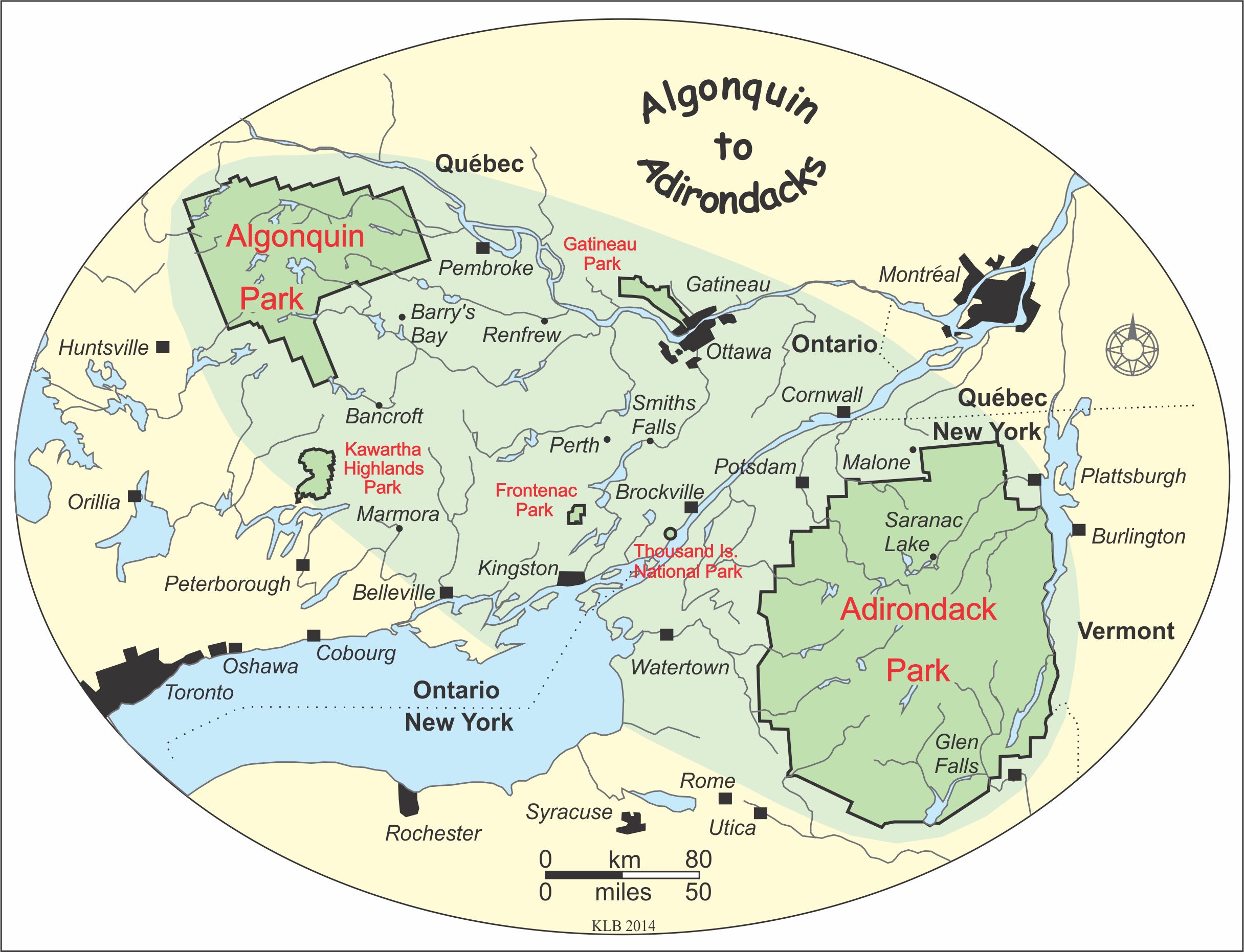
The cities of Ottawa and Gatineau are located within the Algonquin to Adirondacks region. Map by Ken Buchan.
Working alongside Canadian and American NGOs, universities, land trusts, naturalist clubs, government agencies and cottage associations, the A2A Collaborative is:
1. Identifying A2A connections in forests, wetlands, rivers and island chains with comprehensive mapping. Whether it’s large mammals moving through forested landscapes, lake sturgeon migrating within river systems or small mammals and birds utilizing island chains, identifying and recording A2A connections can help ensure they are not severely altered.
2. Identifying threats to A2A connections. Habitat fragmentation, roads/highways, aquatic pollution, hydroelectric dams, proposed tar sands pipelines, climate change, urban sprawl, inappropriate recreational use and wind turbine placement can all compromise the integrity of A2A connections.
3. Maintaining and restoring A2A connections. The collaborative is working with its partners on a number of research and monitoring projects including ones that focus on protecting species at risk (e.g., in watersheds and important bird areas), habitat restoration and road ecology along Highway 401.
4. Developing an online database. To facilitate collaboration and sharing of important information among partners, the collaborative is in the process of creating an online database to catalog data for use by organizations working in the A2A region.
Be sure to visit the A2A Collaborative’s website to learn more about its projects and how you can get involved and support the A2A initiative.

A view from the Precambrian Canadian Shield on the Eardley Escarpment in Gatineau Park, looking east over the Paleozoic sedimentary rocks and farmland of the Ottawa River valley. Photo by Ken Buchan.
